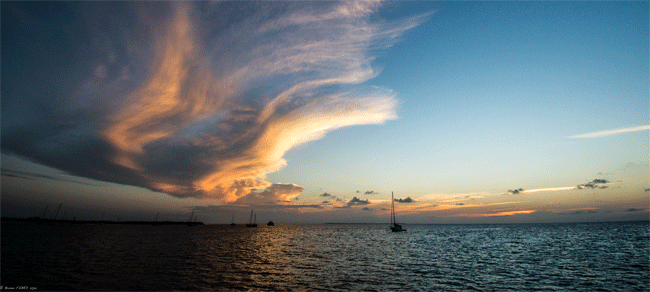
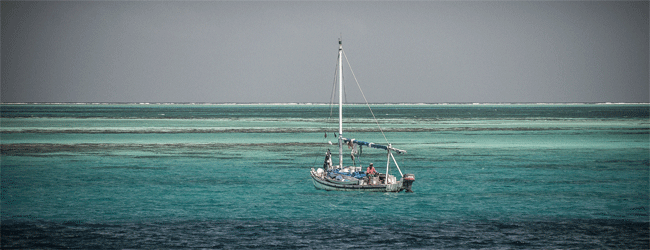
Caye Caulker
The scenery is heavenly : a large turquoise pool bordered by the town, which later
gives way to lush vegetation where some private jetties are emerging, leading to
what we imagine to be thriving villas . Without wind, the anchorage becomes a lake,
and a flight of three rays passes a few meters from the boat in this pool. A dolphin
cruises a little further...
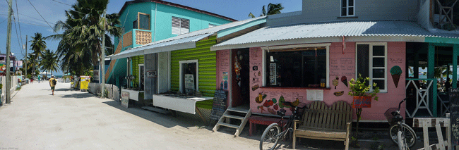
The visit inland confirms this first impression: no roads
but ground or sand tracks, no cars but bicycles and electric golf carts, no McDonalds
but rasta pizzas and ceviches on front of the sea. Local people attrats tourists
to organized tours and sell local fruits and vegetables in the street, the Chinese
hold the stores, tourists stroll in flip flops, casual atmosphere that we value.
To the east of Caye Caulker, the reef protects the lagoon. We attach the dinghy on
buoys where are already moored tourists boats. The node is just tight as the first
rays swim toward us, accompanied by ... nurse sharks. Gulp. Bruno is in the water,
I hesitate, however, given the number of tourists wading, it should not be too dangerous.
Still sharks roaming. Just next to one of the boats, a forest of legs (without fins)
tramples a bunch of rays and unidentified sharks. The screams of some girls probably
fan of "Jaws" are good measure. If one of them is biting it will not make more noise.
Fortunately sharks must be used to serve as a doormat, and the most warlike in this
history is a good sized barracuda that bullhead discreetly around and trying to chopper
pelicans feet wading cautiously.
Bruno offers me to touch a shark, which has a tough
and very rough skin, according to his recent experience. "No I don’t." "Yes you do,
for disinhibiting you" ... "No, I don’t want to disinhibiting !" Finally the GoPro
(underwater camera) and the visible absence of risk is a good way to forget the fear,
and we continue to dance and watching with delight, while remaining measured distance.
Memorable moment !!!
Goff's Cay, RDV Cay, Tobacco Cay, Skiff Sand, many "postcards" anchorages more or
less sheltered, more or less rolly, but still heavenly. We start to explore them
on the 50 miles that separate South Water Caye from Caye Caulker. It is extremely
easy to sail in these conditions, with a little crosswind on a lake, if the time
of high sun are considered, between 10am to 3pm.
Each day is an opportunity for a
new snorkeling, the photo camera and the video camera are out, and even the gun when
we venture deep blue side. All inside areas in the lagoon are nature reserves, guards
surveyed, who run miles and miles motoring to check that we do not hunt in the prohibited
area. They took the opportunity to take us $5 per day per person when they find us.
It's just a shame that our money is not used to develop the moorings with buoys to
protect the anchorages, since apparently fishermen steal it...
The weather remembers
our good memories with a little northern shot, like in Cuba. Within hours, the wind
passes from Southeast to North (via the West), and from 10 to 35kts. Only for fans
of not protected anchorages on the reef... We prefer covered mangrove islands that
offer good shelter. Bluefield Range, then Hutson Cay in the Fly Range, and finally
Blue Ground Range host us time to let the bad weather go away.
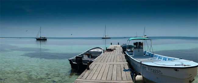
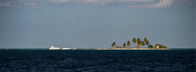
South Water Cay, where reality meets our imagination.
Mythical anchorage : four boats
in the pool, the coral reef three minutes of dinghy away, two channels for teasing
out the blue water, and the "aquarium" spot to Ellen Cay. In the East it’s sunrise
behind the coconut trees, in the West it’s sunset that cut the relief of the coast
of Belize.
Snorkeling outside the reef is spectacular in 5-
Belize is primarily known for its atolls, located about twenty miles east of the
Barrier Reef. Curious, we take the road to the South of Glover's Reef on a beautiful
morning of quiet calm.
South West Cays anchorage is not providing good shelter, we
move towards Long Cay island : one hour engine in the lagoon full of coral patches,
patiently circumvented by Bruno looking out forward, showing me the twists and turns
to make. Not sure this tortuous maze has an exit, but we finally arrive carefree
at destination.
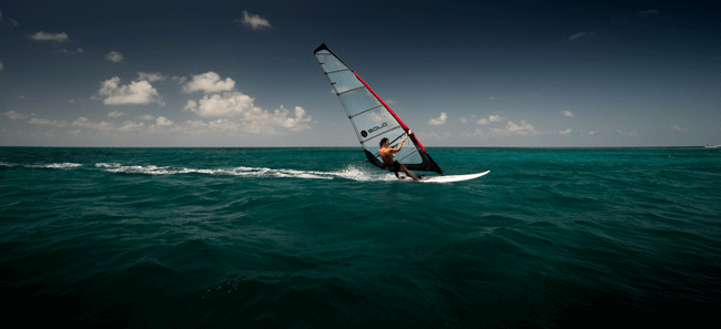
Bruno is already in the dinghy with small rifle and camera, and returns
the "most beautiful snorkeling in his life" with a nice lobster! As for me, it's
finally time for windsurfin, in 17nds of wind that aerate the anchorage. DeLuxe spot
for a session of a lifetime! Returning back to the beach in the slightly chop to
end up with anthological jibes in the hotel pool (and under the puzzled look of guests)
is fabulous, I really enjoy.
A small landtrip for discovering this holidays destination
little known from French : we visit the two "adventure camp". One is specialized
in diving, the second in all kinds of marine activities, highly equipped with sea
kayaks, paddle board, windsurfing ... The water comes from rain, wind from electricity,
customers from US , food from Saturday supplies, the internet from sky by satellite.
Almost self ! The island is covered with a nice mix of tamed jungle, very authentic
and Belizian, well done !
After a few days in this paradise for lovers of beauty
lost corners, the wind finally calm, allowing an exit of the lagoon through the channel
that was sweeping and kept us prisoners, quite against our will !!!
Heading LightHouse
Reef, 35 miles north of Glover's, where we expect THE National Monument of Belize,
the must of Unbelizable: the Blue Hole!!! Not to spoil, the little under sail sailing
ends with a last long slide for Thetys downwind of the reef, outside then without
coral rocks and without a wave, headphones on and the skipette at the wheel. Pure
pleasure !!!
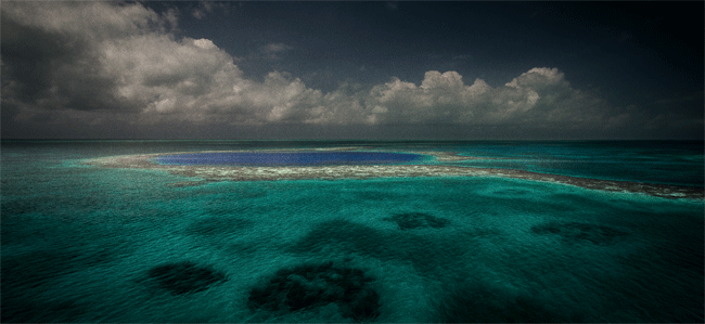
Blue Hole Day
Untraceable, invisible, indescribable ...
Somewhere in the middle of
the Light House Reef lagoon, a blue hole is waiting for us. Myth for divers looking
for originality, local, geological curiosity, or unavoidable for around-
Barely reported by some poles, it is only when we are
less than two hundred yards that we distinguish it. Quickly hoisted up the mast,
Bruno capture photo "from the sky" that best describes this large dark blue circle,
surrounded by green and yellow shoals, with two channels to access with the dinghy.
Here we go!
Pressed and enthusiastic, we reject lunch for a free diving snorkeling
that cannot wait. Equipped with our fins, masks, snorkels, waterproof camera, we
aim the underwater walk that borders the hole itself, about 45 feet deep. Beyond
it's dark and deep a hundred meters. At the launch, some big fish are the welcoming
committee. Posted on the course, the guardians of the temple are made of sterner
stuff: 1 then 2, then finally 5 or 6 large gray shark watching us in our dive. We
see them at the last moment, instantly stopped in our touristic snorkeling ... Turn
around and surface surveillance. They are curious, probably used with divers, this
does not prevent us to be concerned, alone for the daily menu ...
Calmed by this memorable
splash, and to be sure that pleasure is complete, a small wind gets up in the morning,
enough to rig my windsurf... The photographer is motivated, and I appreciate a great
photo session with a few jibes in the blue of the Hole.
It’s already one month as we explore Belize, from paradisiacal anchorages to mythical
atolls, from exceptional snorkeling in magical windsurf sessions, stomach full of
lobster and fish of all kinds.
Time flies, Mexico and the Bahamas are still in our
program before the start of the hurricane season in June, we decide to head north.
A glance at the map, Placencia that has good reputation on blogs travelers will be
our exit port.
Actually anchorage is very nice and sheltered, ideal for a bit of
paper work or refueling. Flip-
This visit has been a real shot in the
heart, away from the traditional circuits that run through the eastern Caribbean.
Nearby Cuba explored last year, and Mexico and the Bahamas to come, "West of the
Caribbean" deserves to dedicate a few months, despite the difficult navigation and
miles to go to access to it !
It’s crowded in the pool on this beautiful afternoon: a manatee dives a few yards away, two dolphins cross us in serene waves, rays flee before our bows, a catamaran sailed in the other direction, flashing to pass a monohull under sail, and a set of four barges towed by a small tug slides at the sound of its engine. It moves !
Any new stopover begins with ... sailing. To change the course to the east of the previous ones, it is in the northwest of Cartagena that Belize is waiting for us, 900 miles ahead.
Quick start where Thetys validates 200 miles in 24 hours in a choppy and formed but
bearable sea. After 48 hours of fast and tiring sailing, we reach the shallow banks
that lie off the coast of Nicaragua. A huge plate with 20m depth only, where sailing
becomes fun: spinnaker, gennaker, pancakes, long hours of reading, drink (non-
The end is more difficult. Return of the wind
and the wave pool. Like a laundrymat. Thetys wiggles around, the pace is chopped,
even the “skipette” is tired of this rythm. Like what offshore nothing is ever granted,
and you have to enjoy the good times to absorb the worst.
Finally
After sailing, administration time ! The narrow entrance of the Marina Cucumber is
blocked by a sand bar announced at 5” high tide. Good thing it's right depth of our
keels… A restaurant occupies the end of the pier, reggae cradles the marina, the
atmosphere is rasta, nice.
Half an hour later, the parade of authorities onboard
begins. Four strong guys invade the cockpit. Forms filling is simple but takes time,
English speaking, as it’s the official language in Belize.
The early atmosphere a bit stuck and official relaxes. We have nothing to declare:
no ammunition or firearms, or stowaways, or hidden diseases. Healthy and finally
stamped able to spend one month in Belize, renewable. Custom, Immigration, Public
Health, Agriculture, Port Authority, $200 and they leave with a smile.
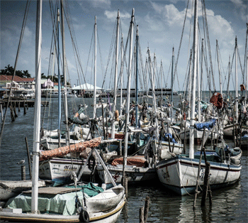
The walk "in
town" tempts us. Except that Belize City, 15 minutes by taxi, former capital of Belize
and 70 000 inhabitants, proves disappointing, even chilling. Dirty city, potholed
streets, surly characters hanging around with ordnance eyes and stopping us every
3m to ask for something in an English rolling the "r" more than difficult to understand.
According to our taxi driver the cross streets are cut-
The next day, lesson # 1: how to navigate the shallow waters of the vast lagoon of Belize ...
We have well read up our "Belize for Dummies": Google Earth, nautical guides, paper
and electronic charts, blogs from other boats ... In reality, the channels are possibly
marked by tripod and other stakes with real heading to respect, false waypoint to
verify insight, and depths around 6-
In any case, we will make progress lagoon color chart: from green to blue, dark or
light, sometimes brown, dusky when a cloud is inserted, the scale remains to define,
test, and validate that the coming months will leaves no marks on Thetys hulls.
To access to the pictures album of the news : click here